Directional Winds in Holocene Create Unique Landforms and Large-Scale Dusty Haze days in the East of China
Y Ding*, 1, HW Lu2
1Earth Science Museum, Hebei GEO University, Shijiazhuang, China 050300
2Forestry and Grassland Administration in Ulanqab City, Inner Mongolia 012000
*Corresponding author: Y Ding, Earth Science Museum, Hebei GEO University, Shijiazhuang, China 050300.
Received: 21 March 2024; Accepted: 28 March 2024; Published: 12 April 2024
Article Information
Citation: Y Ding, Hw Lu. Directional Winds in Holocene Create Unique Landforms and Large-Scale Dusty Haze days in the East of China. Archives of Microbiology and Immunology. 8 (2024): 125-131.
View / Download Pdf Share at FacebookAbstract
Scientists have divided China into three stages from the West, with high altitudes 8,000 meters above sea level, to the East, under 500. The directional wind from West to East not only creates unique landforms such as continent tablemount, boat-shaped Yardang, and layer-fissured granite with geo-tourist value but also blows soils and dust to make a thick dust hood in the East, making it difficult for pollutants, car exhaust, and industrial gases to dissipate. Eastern China has become the most notorious worldwide with too many dust and haze days. The article points out that rock fragments and soils will eventually migrate to the East by directional winds and rivers, which is inevitable, but keeping moisture in the surface soil in the arid areas of the West will alleviate affections of dust and haze days for the East. Canada is one of the countries in the world naturally preserving its beauty by enacting laws that prohibit biodegradable leaves, crops, and branches from being garbage. Biodegradation is a simple way to improve the environment, and every Chinese person should learn and take action.
Keywords
<p>directional wind, landform, pollution, haze, China, Holocene, tablemount</p>
Article Details
1. Background
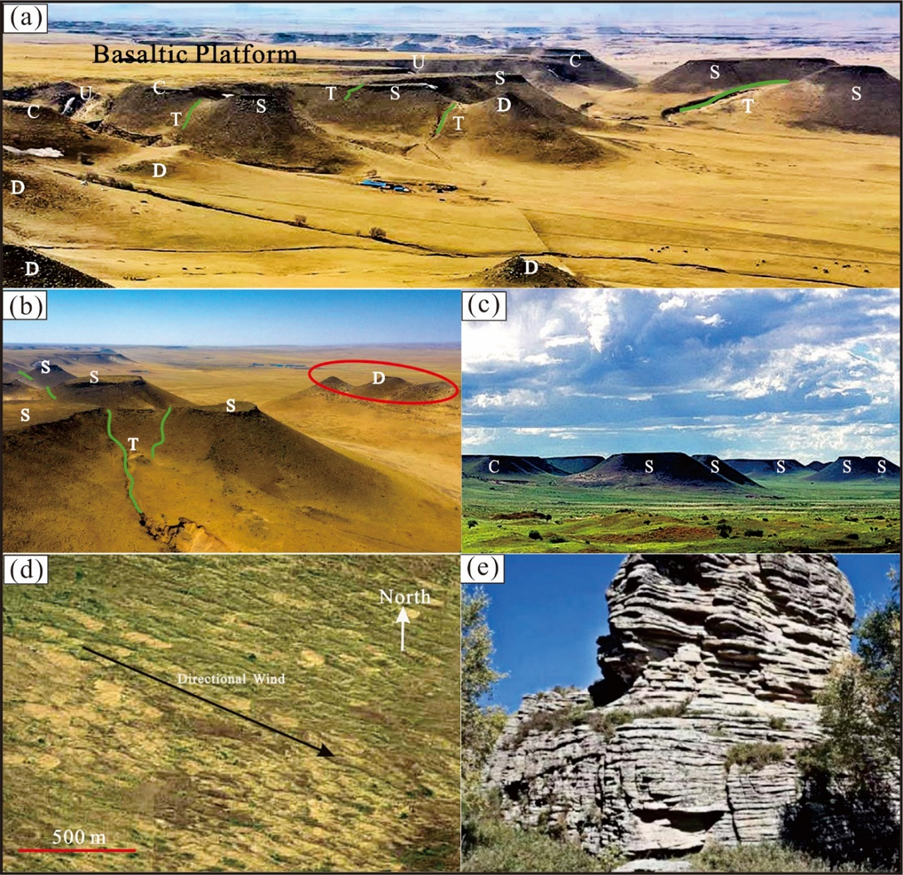
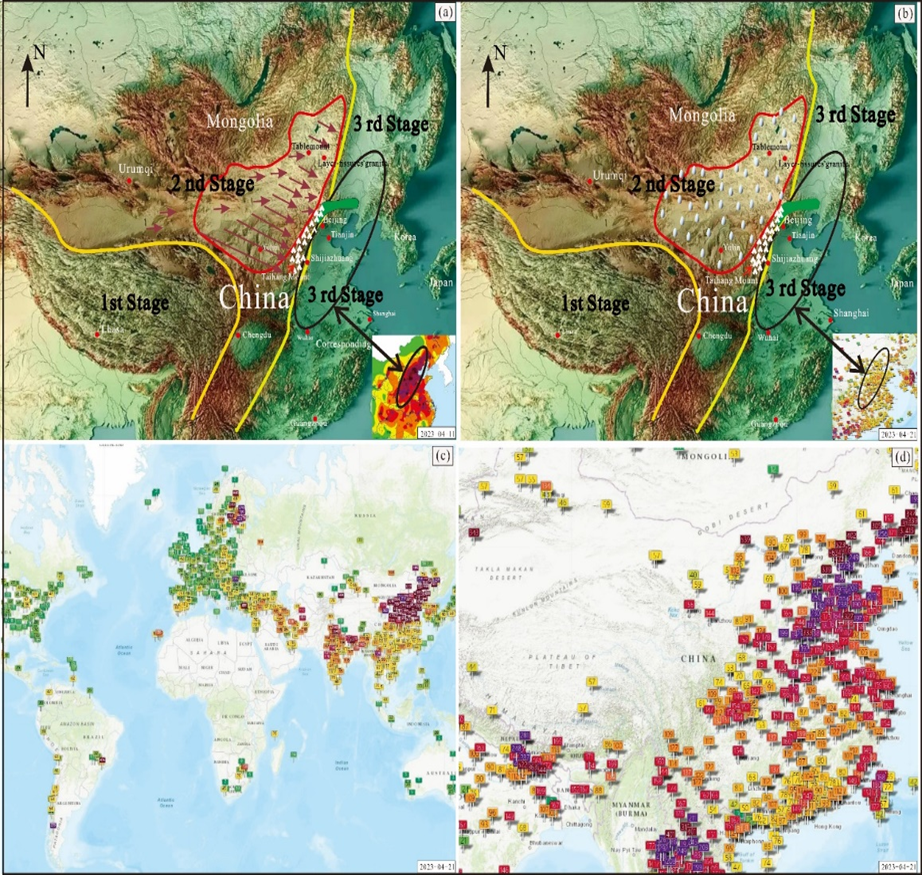
Directional wind refers to the wind blowing in a specific direction within an area. The research on directional wind is for wind power generation and its impact on long-span bridges. In the Holocene, directional winds form because of topographic terrain from higher to lower and through geographic passages like gorges, canyons, rifts, etc.. The characteristic of China's geography is high in the West and low in the East. The wind direction is always from the northwest to southeast, intensive when getting into narrow subsidence-like rifts, creating unique landforms: tablemount (Fig. 1(a)-(c)), Yardang landform (Fig. 1(d)), and layer-fissured granite (Fig. 1(e)). Blowing from the West to the East, the wind picks up loose surface soil and makes thick dust hood sky, resulting in dust-haze (DH) days (Fig. 2(a) (c) (d)). The hood resists diffusion of unhealthy air-out. While entering China from North America, pilots see a big difference in air quality between North America and China. People in Beijing and Shijiazhuang can see a layer of dust on their cars every day, even the dust affecting neighboring countries. Increasing the moisture of the topsoil in the 2nd stage will significantly alleviate the atmospheric dust cover of the 3rd stage to decrease the polluted weather for the East of China (Fig.2 (b)).
Figure 1: Drone photos and field photos. Drone photos (a) and (b) and field photo (c) on the tablemount landform, located 30 km south of Xilinhot City (see Fig.2(a) for the location). In (a)-(c), C is the connected tablemount, S stands for the separated tablemount, D symbols for the Dwarf mound, trickle (T), depression (U), and cutting (V) ditches. There are 43 of them distributed within 1 km from the edge of the lava platform. C is close to, S farther away, and D is the farthest from the basaltic platform, indicating that the formation time of C is earlier than that of S and D. The abrasion by the directional wind made “D” disappear earlier [the red cycle in (b)]. (d) Satellite Image of boat-shaped Yardang landform south of the Xilinhot City, which follows yearly directional wind from NWW to SEE. (e) a field picture of layer-fissured granite.
Figure 2: (a) and (b), the topographic maps of Eastern Asia. (a) The two yellow lines divide China into three stages from higher (the 1st stage), with an altitude over 4,000 meters above sea level, to lower, with a height below 500 meters in the East (the 3rd stage). The directional wind blows from the northwest to the third stage in the East. In addition to sculpting distinctive landforms (the tablemount and the layer-fissure granite, the red points for their locations), directional winds have caused nearly 700 million people in the East to be shrouded in dust and haze (black circles), which dust cloud even floats to Korea and Japan. Since the year of 2000, the Chinese government has invested over 40 billion yuan in constructing protective forests (the solid green area) in Beijing, Tianjin, and Hebei province in a failed result that could slightly change dusty weather. In the place by the red line, directional winds that pick up and raise soil a height of 8 kilometers keep drifting to the Eastern region every year, which should be an exact area Chinese government invests in vegetation coverage to keep moisture and carbon in soils to reduce the dust and haze weather in the East. The embedded small map is the average concentration distribution map of PM2.5 in the 11th of April in Eastern China in 2023, in which the red square is the most painful area (PM2.5>250, red-brown square is between 116-250). (b) The topographic map of Eastern Asia, 2023-04-21. The rainfall happened for the dry area in the 2nd stage on April 21, 2023, and there was no haze and soil weather in the East for the date and the week later, which inserted map indicates the relatively healthy weather by the yellow square (PM2.5<75) on the day (the source is from https://aqicn.org/map/china/cn). (c) Global map of the air quality index dated 2023-04-11, displaying the worst unhealthy air pollution (dark brown) in the East part of China. The source is from https://waqi.info/cn. (d) Real-Time Air Quality Index Map on China, 2023-04-11, the black brown squares indicate the unhealthiest, and the red is next. The source is from https://aqicn.org/map/china/cn
2. Directional winds create unique landforms
The three geographic stages in China
They are from west Tibet to east Beijing and Tianjin, i.e., high to low. Scientists divide this vast area, 5,000 km across, into three stages according to their altitude (Fig. 2(a)). The Tibet plateau, with over 4,000 meters above sea level, is the 1st stage. The 2nd stage has a vast area between 4,000 and 1,000 meters with about 4.5 million square kilometers. The height of the Taihang Mount (Fig. 2(a), (b)) is from 500 to 1000 meters above sea level, the transitional zone between the East and West of China. The 3rd stage is in the East, where densely populated and industrially developed compared to the West of China. The directional wind in China is mostly NWW to SEE, that is from high to low altitude. The development direction of the following three landforms is consistent with the direction of the wind blowing.
Tablemount on land
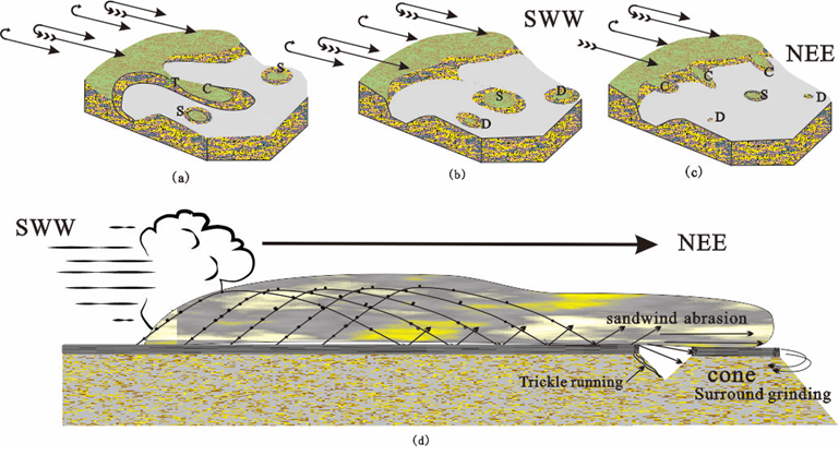
The Guyot landform, tablemount, is a flat-topped cone on the Pacific seafloor found in 1946 [1-3], but the tablemount on land is rare. Groups of flat top cones (Fig.1(a)- (c)) exist along the edge of the basaltic lava platform in Xilinhot League, Inner Mongol Region of China. The studies by different geological methods have confirmed these flat-topped cones are not volcanic ones, having characteristics that their tops do not have vents that would be lower at the center than their edges if they are volcanoes, their tops have irregular shapes, their heights are same as the platform from which cones evolved. Furthermore, the cones compose of two layers with basaltic layer of 9 meters in thickness on the top and sandstones at the base, the formation of Late Cretaceous [4]. The exciting thing is that three kinds of cones are in an arrangement from near to away from the basaltic platform, which is "connected to the basaltic platform (C)," "separated (S)," and "dwarf mount (D)" (Fig.2(a)-(c)), showing they are from younger to older and the oldest, D, will disappear soon (Fig.3). The directional winds formed through the rift, subsidence in the area, become stronger (the small arrows in Fig. 2(a), as the primary erosion agent creates this kind of the unique landform - tablemount on land.
Figure 3: Schematic diagrams of the evolution of flat top cones in Xilinhot, demonstrating an evolution trend. (a) Formation of the C cone. The wind blows in an SWW to NEE direction when C cones form first, then to S cones; (b) Wind blow results in the C cone becoming separated (S cone), S cones to dwarf mounts (D). (c) Year after year, the new C cones were born. The old separated ones (S) were weathered to disappear (D). (d) Arid weather makes it easier for the directional wind to pick up sands and soils that roll, forming sand wind, a powerful weathering agent in creating the tablemount landform.
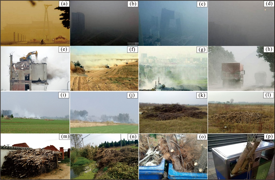
Figure 4: Field pictures in China. (a)-(d) are the photos of DH days in Beijing, Tianjin, and Shijiazhuang. (e)-(h) are some human activities in the West of China, arid areas, (e): demolishing buildings, (f): plowing, (g): a garbage disposal place near a town, and (h): dust rise by truck running in the 2nd stage. (i)- (j) Burning straw is common in rural areas. (k)- (p): straw, tree leaves, and tree branches are treated as garbage.
Boat-shaped Yardang landform
The internationally accepted landform “Yardang” has origin in Uygur language, Xinjiang of China. The word is the formal expression in the early 20th century, meaning a weathering landform, mainly ridge-like, castle-like or hill-like in extremely arid region. The boat-shaped Yardang landform (Fig. 1(d)) extends along the directional wind in many locations in a vast area of Inner Mongolia, China. The yearly directional wind is carving from fissures to ditches on sedimentary rocks.
Layer-fissured granite
Rare in the world, the landform is located at Xilinhot League, a prefecture in the Inner Mongol Autonomous Region of China, where the government built the geologic park. Many locations in the region have “layer-fissured granite” (Fig.1(e)). Looking from a distance, people might judge these granitoid rocks had layers as sedimentary rocks. However, the granite is compact with composite minerals arranged in a state of disorder. The fissure in the granite extends parallel to the terrain trend, which angle accords up and down with the hill slope. These fissures are resulted from carving by directional wind blowing with sand, indicating the wind is so strong in these regions.
3. Directional winds result in unhealthy atmosphere in the East
The DH days in the East
PM2.5, an index parameter for measuring air, has a particle size less than or equal to 2.5 μ. Although the delicate particulate matter is only a small component of the Earth's atmospheric composition, it significantly impacts air quality and visibility since it may contain many toxic and harmful substances that directly affect atmospheric environmental quality near the Earth's surface [5]. When a 1~8 km thick dust cloud blowing from the West (Fig.1a) forms a hood above the East, industrial and automotive exhausts cannot disperse. Toxic gases stay near the surface of this area for a longer time. The DH-Day pattern in China is generally less in the West, more in the East (Fig.2(a)(d), more in urban areas, and more in the winter and spring seasons between Nov. and April. When the dust hood is over a city, the weather atmosphere becomes terrible with poor circulation, especially without cold winds during winter, unfavorable for pollutant diffusion and zonal pollutant area forms. The abnormally high amount of NOx during the DH episodes, produced by fossil fuel combustion and vehicle emissions, played a direct role in the rapid secondary transformation of SOx into sulfate aerosols. SOx, NOx, and other primary gas pollutants transformed into secondary aerosols (e.g., sulfate and nitrate) through heterogeneous reactions on the surface of carbon-containing ultrafine particles [6]. Significant regional affections exist in the impact of PM2.5 pollution on public health [7].
The forestation blockage surrounding the northwest edge failed
In the past 30 years, China has invested a lot of money and workforce in the afforestation and desertification control on the north edge of the 3rd stage and urban forestation. The local governments (Beijing, Tianjin Cities, and Hebei province) have invested over 50 billion yuan since 2,000 to have built protective forests, covering 200 km2 (Fig. 2(a)), with over one hundred million people participated. The data in recent years show DH days are still going on (Fig. 2(a) (d)). The foresting approach might improve the local atmosphere only, which definitely could not reduce DH days and times of sandstorms coming from the West. Without dealing with the dust source in the 2nd stage (the red line cycle in Fig.2(a)), the local effort can only slightly change the local weather and create visional effects. The green block (Fig.2(a)) has failed in retarding any amount of soil movement from the West to the East, since the dusty strata in the air move primarily up to 1-8 km high. Beijing, Shijiazhuang, Chengdu, etc. cities (Fig.2(a)) are located beside mountain ranges which cause poor air circulation [8]. The situation of soil and sandstorm spreading to the East and the formation of the worst pollutant days occurred during the four months of 2023 (Fig. 4(a)-(d)). To alleviate the haze affection, artificial precipitation in urban haze areas was adopted to mitigate DH effects [9], but the author thinks the approach is only creating temporary moisture and fresh air locally, not solving the root problem. The research [10] on the eonian-sand section in Yulin (Fig.2(a) for the location) tells that in the early Holocene (11,500~10,000 BP), magnetic susceptibility, clay, and silt contents increased gradually and relatively humid, expanding vegetation coverage, not much sandstorm happened during the period of 10,000 and 4,500 BP. Since nearly 3,000 years ago, significant climate aridity has come back with coarsening of sandstorm sediments, which is probably reacting from human activities that are central to environmental changes.
The key point is to keep moisture in the soil of the 2nd stage
Scientists unanimously believe the Republic of Mongolia to be the source of sandstorms, which happens a few times a year. The author thinks that the country is not a primary agent that makes the dust hood every day for the East of China. The coalition with the Republic of Mongolia would help decrease times of stormy weather and may reduce soil and sand movement to the East. When the windy days happened in the area in the 2nd stage delineated by the red line in Fig.2(a), including Qinghai, Gansu, Ningxia, Inner Mongolia, Shaanxi, Shanxi provinces, and part of the Taihang Mountains of Hebei province, arid area in China, the unhealthy atmospheric sky covered the East. The soil and dust could ascend to 1-8 km high in the West by wind picked up and raised by human activities (Fig.4(e)-(h)) in the dry area. For instance, just a jeep running can raise loose soil to 1-8 km high. Think about it, if a tornado in the Midwest of the United States occurs in arid areas without much moisture in the topsoil, the entire United States would be shrouded in DH pollution days for several months. The author has noticed that when rainfall in northwest China began, no DH occurred for several days in the East (Fig. 2(b)). Decreasing soil rise by keeping moisture in the topsoil in this vast area in the 2nd stage is a key that can reduce the dust hood to the East, further decrease DH days for the East.
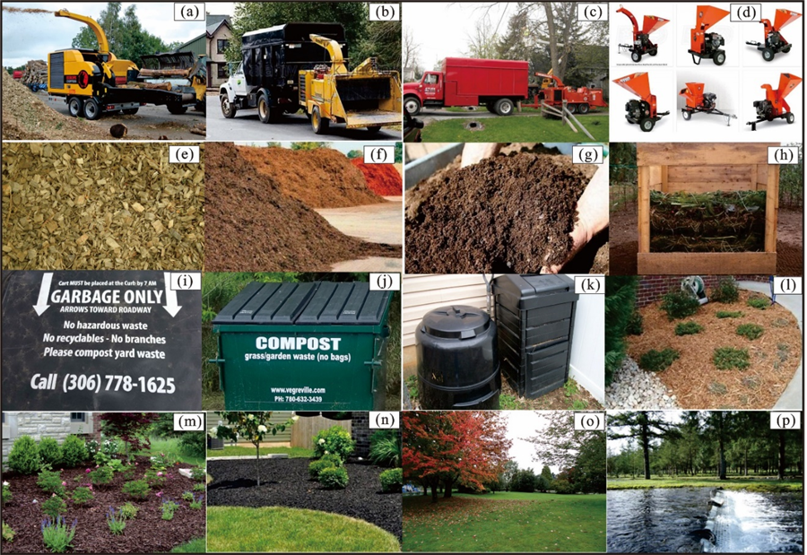
The rock in the western mountain in China will break and eventually move to the East, which is inevitable, but humans can take various methods to alleviate it. In ancient China, farmers rolled stone tubes temporarily to compact the topsoil after the autumn harvest to prevent it from being swept up by the wind. Unfortunately, nowadays, peasants have abandoned this method. Biodegradation is another way of keeping moisture in the soil, i.e., returning carbon-hydro compounds such as plant leaves and branches or crop branches by shredding them back into the ground. However, this method has yet to be used in the area of the 2nd and 3rd stages. In the rural area in the 2nd and the 3rd stage, it is common to see that peasants burn crops or tree branches at night, even during daytime (Fig.4(i)-(j)) for cooking, warming, or other purposes, is a result of smoke floating to the East and covering the East during the daytime. The author investigates a broad part of these regions for years in China and finds there is no law or regulation related to biodegradation, no crushing machines (Fig.5(a)-(d)) to have been used, and residents and peasants treat plants as garbage (Fig.4(k)-(p)).
'Biodegradation' here refers to shrinking, by using machines, leaves, branches, trunks, and debris grass, as well as straw from sunflowers, sorghum, corn, etc., into centimeters in size (Fig.5(e)), and biological effects appear as fertilizers (Fig.5(f)-(h)) generated during accumulation (Fig.5(j)-(k)). Finally, Organic soil with reduced volume to black, in which way when back to soil increasing moisture and carbon in the top soils to be less picked up by wind. The degradation methods are moisture conservation practices, restoring the C (carbon) element to nature.
China should learn from Canada
Located in the southern part of Alberta, Canada, and to the East of the Rocky Mountains, Calgary City has won awards in the World's Best Livable City Awards every year. The cities nearby the Rocky Mountains suffer directional winds every year from the Rocky Mountains. However, to keep moisture in the topsoil, all provincial governments legislate biodegradation by law (Fig.5(i)) that materials such as tree leaves or brunches are not garbage and should be degraded and returned to nature (soils) (Fig.5(l)-(n)). There are shredding centers to deal with these materials if residents cannot crush them by their machines or hiring professional companies to process tree or shrub branches or leaves. The degradation of hydrocarbons in nature has become deeply ingrained in Canadians for more than 40 years, having endeavored natural beauty (Fig.5(o)-(p)).
Figure 5: Field pictures taken in Canada show residents' environmental awareness, crushing tree branches by professional companies (a-c), clipping machines (d), chips (e), compost (f-h), different styles of containers stored garbage or composts (i-k), and compost coverage on bare topsoil (l-n), some beautiful scenes in BC province of Canada, showing colorful autumn and salmon fish run (o-p).
Conclusions
The directional wind carves the tablemount on land, boat-shape yarding, and layer-fissured granite, all rare worldwide. The directional wind picks up loose soils in the dry areas and blows them to lower terrain to form the hood to resist air circulation, creating an unhealthy atmosphere in East China. In the 2nd and 3rd stages, the Chinese governments should legislate by law on biodegradation, returning C-H compounds to nature to keep moisture in the topsoil and improve soil quality in the 2nd stage, for a long-time effect to have fewer dust-haze days in the East. Due to the influence of natural weathering, after a specific geological period, the rock fragments and soil in the 2nd stage are eventually moving to the 3rd stage, which is an inevitable trend. Humans can use various methods to delay or alleviate this movement. Biodegradation is a simple way to improve environment that every Chinese should learn and remember.
Acknowledgements
This paper is jointly funded by the application project of Ulanqab National Geopark (No. 02020079) and the planning project of Ulanqab National Geopark (No. WSZCS~C~F~210091)
References
- Britannica (2020). Definition of Guyot. Retrieved on from https://www.britannica.com/science/guyot.
- Webster (2020). Definition of Guyot. Retrieved from https://www.merriam ~webster.com/dictionary/guyot, on 2020~9~9.
- Winterer EL, Natland JH, van Waasbergen RJ, Duncan RA, McNutt MK, Wolfe CJ, et al. Cretaceous guyots in the NorthWest Pacific: An overview of their geology and geophysics. In: Pringle M S, Sager W W, Sliter W V, Stein S. eds. The Mesozoic Pacific: Geology, Tectonics, and Volcanism: A Volume in Memory of Sy Schlanger. Geophys. Monogr. AGU, Washington, D. C.Ser vol 77 (1993): 307-334.
- Bureau of Geology and Mineral Resources of Inner Mongolia Autonomous Region. Lithostratigraphy of Inner Mongolia Autonomous Region, edited by Li Wenguo, Li Qingfu, Jiang Wande et al. China University of Geosciences Press, Wuhan (1996): 305-306.
- Zhang YL, Cao F. Fine particulate matter (PM2.5) in China at a city level. Scientific Reports 5 (2015): 14884.
- Wang YS, Yao L, Wang LL, et al. Mechanism for the formation of the January 2013 heavy haze pollution episode over central and Eastern China. Science China: Earth Sciences 57 (2014): 14–25.
- Shen J. Research on Public Health and Socio-economic Impacts of PM2.5 Pollution. China University of Geosciences, Wuhan China (2018).
- Liu WH, Zhao XL, Wang CX, Yang JC. Characteristics and Formation Mechanism of a Heavy Air Pollution Episode in Zigong. Plateau and Mountain Meteorology Research 38 (2018): 73-77.
- Pei Z, Gu KL, Yang YL. Modeling and Analysis of Alleviating Effect of Artificial Rainfall on Urban Haze. Environmental science and management 48 (2023): 92-96.
- Chen SE, Fan SH, Liu XH, Dong HW, Lu L, Wang LL. Holocene Climate and Environmental Changes in the Eolian Sand Section of Yulin, Shaanxi Province. Journal of Earth Sciences and Environment 32 (2010): 81-88.


 Impact Factor: * 3.5
 Acceptance Rate: 71.36%
  Time to first decision: 10.4 days
  Time from article received to acceptance: 2-3 weeks
