Assessment of Secure Exploitation Reserve of Groundwater Source in Camau Peninsula, Vietnam
Nguyen Dang Tinh1 ? , Phan Thai Le2, Dong Uyen Thanh3, Nguyen Ngoc Quynh4, Ngo Duc Chan4
1Thuy Loi University, Hanoi, Vietnam
2Danang Water Supply Joint Stock Company, Da Nang, Vietnam
3Faculty of Geology and Petroleum engineering, HoChiMinh City University of Technology, Ho Chi Minh City, Vietnam
4Division for water resources planning and investigation for the south of Viet Nam (DWRPIS), Ho Chi Minh City, Vietnam
*Corresponding Author: Nguyen Dang Tinh, Thuy Loi University, Hanoi, Vietnam
Received: 12 February 2020; Accepted: 25 February 2020; Published: 25 March 2020
Article Information
Citation:
Nguyen Dang Tinh , Phan Thai Le, Dong Uyen Thanh, Nguyen Ngoc Quynh, Ngo Duc Chan. Assessment of Secure Exploitation Reserve of Groundwater Source in Camau Peninsula, Vietnam. Journal of Environmental Science and Public Health 4 (2020): 005-015.
View / Download Pdf Share at FacebookAbstract
In the Camau Peninsula, groundwater is an important freshwater source, which has been being exploited and used widely, playing a very important role in the progress of socio-economic development in the localities in the Peninsula. However, due to the local natural characteristics, the law of distribution of good quality water is complicated by the presence of saltwater layers in the aquifers, causing many difficulties in the exploitation and usage of the fresh groundwater. The paper uses data collected from the studies of specialized agencies and localities that have been implemented so far. The study results show that potential groundwater exploitation reserve is 11,340,100m3/day and secure exploitable groundwater reserve is 741,500m3/day for the entire Camau Peninsula.
Keywords
<p>Camau Peninsula, Hydrogeology, Groundwater, Potential exploitable groundwater reserve, Secure exploitable groundwater reserve</p>
Article Details
1. Introduction
Secure Exploitable Groundwater reserves of a groundwater basin or aquifer system is defined as the amount of water that can be exploited from it without producing an undesired effect [1, 2] secure exploitable groundwater reserves yielde limit to the quantity of water which can be exploited regularly and permanently without dangerous depletion of the storage reserve. He was also the first to recognize the need to reserve a fraction of the recharge for the benefit of the surface waters and related ecosystems [3]. realized that all groundwater is formed by continuously moving through a porous environment, from the recharge zone to the discharge area. He recognized that in its pristine condition, the aquifer was in an approximate dynamic equilibrium. Until groundwater is extracted (drained by pumps), the aquifers will form a new balance by: increasing the natural recharge capacity; reduce natural emissions; loss of storage in aquifers; or combine them.
Hydrogeological study for an area in Viet Nam, determination of groundwater exploitable reserve is a usual obligatory requirement. Depending on concrete investigation stage or requirement of a project, a grade of reserve will be determined. As for detailed investigation projects (groundwater exploration, exploitation license), an exploitable groundwater reserve must be determined for well fields. As for general groundwater investigation or preliminary groundwater investigation projects, just potential exploitable groundwater reserve determined with balance method is required. In trend of sustainable development, secure exploitable groundwater reserve is oriented. It is essential information for groundwater resources planners and managers. Potential exploitable groundwater reserve is a common question in hydrogeological study. There are methods for its determination. However, once this groundwater exploitable reserve is totally exploited, the groundwater resources will be degraded. In natural conditions such as in Camau peninsula, groundwater exploitation usually induces salinity intrusion (vertical and horizontal). Therefore, how much groundwater can be exploited to assure sustainable development purpose? This question is related to secure groundwater exploitable reserve. As a result, a maximal quantity of groundwater must be determined such that the sustainable development purpose be assured. In this paper, question of sustainable groundwater exploitation is approached by determination of secure exploitable groundwater reserve with groundwater flow modeling in combination with groundwater sustainability index [4].
This index is calculated with formula:

I <90%: Sustainable; I = 90 ÷ 100%: Less sustainable; I ≥ 100: Unsustainable; Total exploited amount: is calculated after data of actual groundwater exploitation status; Total recharge amount (natural): is determined with digital modeling.
In Camau peninsula, main groundwater recharge is dynamic reserve generated from horizontal and vertical filtration, including both fresh and saline water modeling method is a most suitable mathematical tool for calculating total annual fresh groundwater recharge in a concrete region.
Total recharge amount is calculated as total flow in amount or total flow out amount in groundwater balance. Therefore, to determine secure exploitable reserve in Camau peninsula the author will rely on total flow in amount based on groundwater balance of the groundwater model for fresh groundwater area, not including filtration flow in from saline groundwater area (Figure 1).
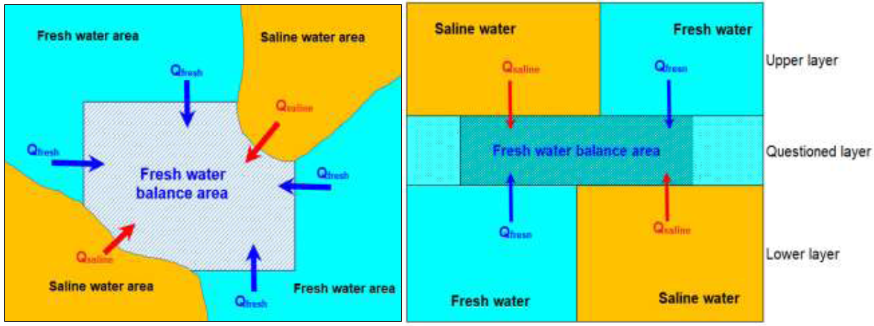
Figure 1: Scheme of flows to balanced area (zone budget) horizontal (right) and vertical (left).
Used data are original data of previous studies of the former Department of Geology and Minerals and recent collected data. Data are summarized and processed in accordance with hydrogeological stratification orientation [5]. Information in this paper (calculation results, digital model and maps) are data recently implemented by group authors in the theme KC08.08/16-20.
|
# |
Aquifers |
Areas (km2) |
Areas by regions (km2) |
|||||||
|
A |
B1 |
B2 |
B3 |
C1 |
C2 |
D |
E |
|||
|
1 |
qh |
8,052 |
3,826 |
1,482 |
1,558 |
181 |
183 |
18 |
602 |
201 |
|
2 |
qp3 |
14,545 |
4,332 |
1,482 |
1,923 |
968 |
2,177 |
1,025 |
1,086 |
1,553 |
|
3 |
qp2-3 |
16,564 |
4,332 |
1,482 |
2,083 |
1,132 |
2,177 |
1,053 |
1,254 |
3,051 |
|
4 |
qp1 |
16,667 |
4,332 |
1,482 |
2,082 |
1,132 |
2,177 |
1,052 |
1,359 |
3,052 |
|
5 |
n22 |
16,092 |
4,332 |
1,482 |
2,082 |
1,132 |
1,639 |
1,015 |
1,358 |
3,051 |
|
6 |
n21 |
15,580 |
4,332 |
1,482 |
2,082 |
1,132 |
1,448 |
688 |
1,365 |
3,051 |
|
7 |
n13 |
14,111 |
4,149 |
1,482 |
2,082 |
1,132 |
572 |
286 |
1,357 |
3,051 |
Table 1: Horizontal distribution of aquifers.
|
# |
Aquifers |
Top depth (m) |
Bottom depth (m) |
Thickness (m) |
||||||
|
From |
To |
Average |
From |
To |
Average |
From |
To |
Average |
||
|
1 |
qh |
0.0 |
61.0 |
19.6 |
8.0 |
75.0 |
30.8 |
0.6 |
65.0 |
11.3 |
|
2 |
qp3 |
20.0 |
94.5 |
46.3 |
29.0 |
162.0 |
71.7 |
1.9 |
122.4 |
25.6 |
|
3 |
qp2-3 |
44.0 |
162.0 |
85.1 |
62.2 |
207.0 |
127.2 |
2.0 |
109.5 |
42.1 |
|
4 |
qp1 |
85.5 |
226.0 |
147.0 |
108.0 |
287.2 |
186.9 |
3.0 |
110.2 |
39.9 |
|
5 |
n22 |
130.0 |
310.6 |
210.6 |
144.0 |
334.0 |
256.9 |
3.0 |
133.0 |
46.3 |
|
6 |
n21 |
149.0 |
363.3 |
283.4 |
180.0 |
408.7 |
328.6 |
10.0 |
139.0 |
45.3 |
|
7 |
n13 |
285.4 |
508.0 |
378.0 |
313.5 |
602.0 |
442.3 |
6.5 |
129.0 |
64.2 |
Table 2: Vertical distribution of aquifers.
2. Characteristics of Aquifers
In Camau peninsula there are 7 granular aquifers, being: Holocene (qh), Upper Pleistocene (qp3), Middle-Upper Pleistocene (qp2-3), Lower Pleistocene (qp1), Middle Pliocene (n22), Lower Pliocene (n21) and Upper Miocene (n13). Spatial distribution of aquifers is presented in (Tables 1 and 2). Locations of fresh saline interfaces are edited based on studied results of Nguyen Huy Dung [5] and updated with recent studied results (Figures 2 to 4).
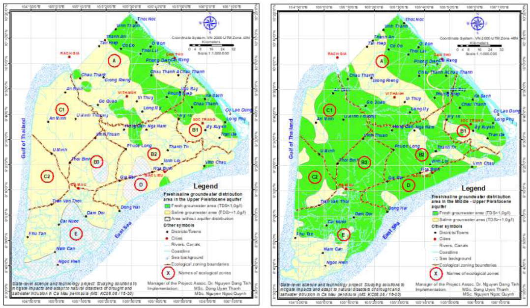
Figure 2: Fresh and saline water distributions in Upper Pleistocene and Middle-Upper Pleistocene aquifers.
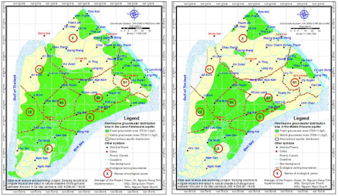
Figure 3: Fresh and saline water distributions in Lower Pleistocene and Middle Pliocene aquifers.
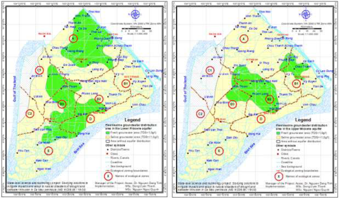
Figure 4: Fresh and saline water distributions in Lower Pliocene and Upper Miocene aquifers.
3. Construction Grondwater Flow Model for Camau Peninsula Area
3.1 Briefly about theory of groundwater flow model
3.1.1 The basic equation: Groundwater is a liquid mineral, so its reserve as well as regime are constantly change. This change is necessary to quantify and correctly describe to serve for problems of reserve calculation, flow, and contaminant dispersion. Most importantly, it supports groundwater resources management and planning. Overall changes of groundwater heads are described by a unique partial differential equation as follows:

- Kxx, Kyy, Kzz : Hydraulic conductivity in x, y and z directions. Z is vertical direction
- h: Head at location (x,y,z) at time point t
- W: Underground flow modulus, or source, sink of groundwater at location (x,y,z) at time point t. W = W(x,y,z,t) is an function of time and space (x,y,z)
- Ss : Specific storage
- Ss = Ss(x,y,z), Kxx = Kxx(x,y,z), Kyy = Kyy(x,y,z), Kzz = Kzz(x,y,z) are functions of spatial locations x,y,z
Equation (1) describes head regime under conditions of heterogeneous and anisotropic medium. In combination with boundary conditions and initial conditions of aquifers, it constitutes a mathematical model of groundwater flow.
3.1.2 Implementation procedure: In combination of specialized hydrogeological theories with mentioned modeling theory, implementation procedure for construction of a groundwater flow model is as follows:
- Data preparation: Schematizing hydrogeological conditions of the groundwater system. Data collection, data processing to match them with the calculating scheme.
- Data Input: Inputting spatial data (attributable properties of layers), initial conditions, timely data (various boundaries)
- Run and Calibration of the model: Choosing time step and running the model for its calibrating. After successfully calibration, next running the model to solve the required hydrogeological problem.
3.1.3 Assessment of simulation quality: Results of the adverse solved problem is required for qualitative and quantitative assessment. After National Research Council (1990), the last purpose of the calibration problem is minimizing error values. There are 3 kinds of errors for assessing differences between monitored and modeled heads, being: i) Mean error (ME), ii) Maximal average error (MAE), iii) Root Mean square (RMS) or standard deviation. MAE and RMS are suitable criteria for assessing quality of the model.
3.2 Groundwater flow model of the Camau peninsula area
The groundwater flow model of Camau peninsula area was constructed with GMS 10.2 software and set of collected data and monitoring data of the groundwater regime in Camau peninsula area.
3.2.1 Schematization of the porous media: Based on natural conditions and hydrogeological setting of Camau peninsula, the hydrogeological problem will be solved with a scheme of 15 layers simulating 7 poorly productive geological formations, 7 aquifers and 1 bedrock layer.
3.2.2 Data input: Coverage are as follows:
- 01 coverage of Recharge – Evapotranspiration (ET) rate: after meteorological data available in concerned provinces;
- 01 coverage of River Head: Head values on boundaries after data of hydrological stations;
- 15 coverage of attributabilities: Horizontal hydraulic conductivity (kh), vertical hydraulic conductivity (kv), specific storage (µ*), storage yield (µ): after pumping data at 306 wells for 15 simulated layers;
- 08 coverage simulating distributions of layers;
- 07 coverage of groundwater abstraction: After exploitation data in the concerned provinces for 7 aquifers (no abstraction from layer 15);
- 07 coverage of monitored heads: Monitoring data at National Groundwater Monitoring Stations for 7 aquifers (no monitoring well in layer 15);
(Figure 5) shows coverage and locations of study wells of lithology and attributable parameters.
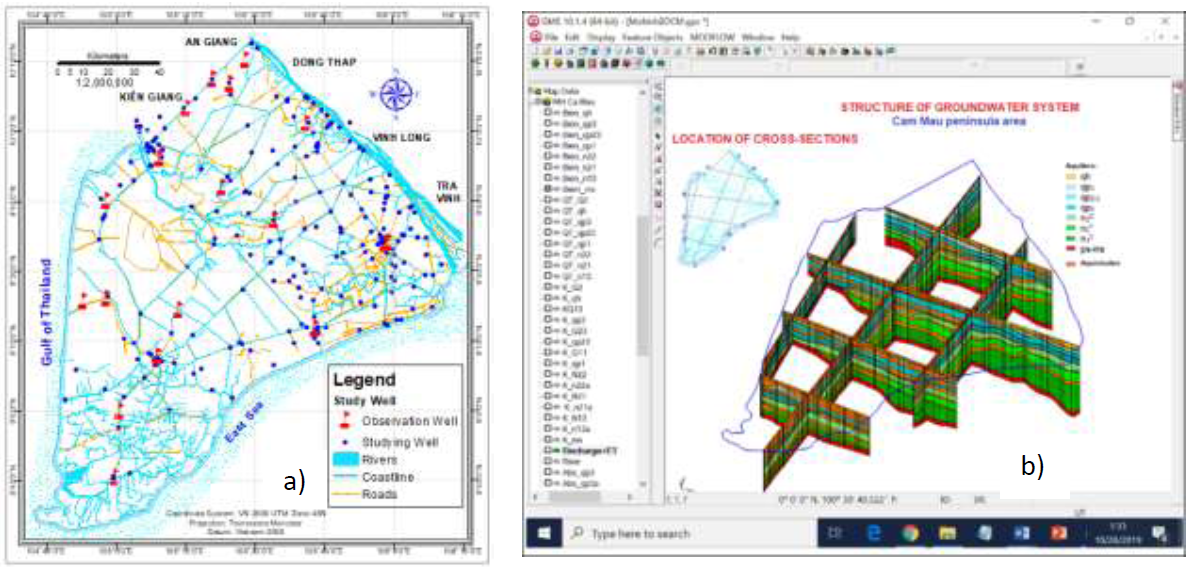
Figure 5: (a) Range of the model and locations of study wells; (b) Spatial distributions of aquifers and coverage.
3.2.3 Simulation time: 36 months (from January 2015 to December 2017).
3.2.4 Results of model calibration: The groundwater flow model of the Camau peninsula uses real monitoring data at 18 locations with 62 monitoring wells for calibration. The resulted RMS for the entire model is in range of ± 0.5m.
4. Results and Discussion
4.1 Potential groundwater exploitable reserve
The potential groundwater exploitable reserve is calculated by balance method with formula: Qkt = Qtl + Qdh + Qd (2) Where: Qtl is Static gravitational reserve; Qdh is static elastic reserve; Qd is dynamic reserve and Qct is induced reserve. Dynamic reserve Qd is determined from flow budget by the groundwater flow model, including induced reserve. The potential groundwater exploitable reserve is evaluated for 6 potential aquifers, being: qp3, qp2-3, qp1, n22, n21 and n13. Aquifer qh and aquifer ps - ms (bedrock) have limited distribution range, small thickness, poor productivity, so no calculation made for them.
|
Aquifer |
Potential fresh groundwater exploitable reserve (m3/day) |
Total (m3/day) |
|||||||
|
A |
B1 |
B2 |
B3 |
C1 |
C2 |
D |
E |
||
|
qp3 |
433,679 |
170,785 |
36,575 |
0 |
0 |
0 |
14,571 |
0 |
655,611 |
|
qp2-3 |
887,558 |
387,348 |
532,591 |
322,987 |
544,772 |
242,478 |
329,285 |
529,664 |
3,776,684 |
|
qp1 |
439,591 |
279,629 |
394,524 |
313,125 |
311,600 |
248,521 |
403,621 |
627,469 |
3,018,079 |
|
n22 |
198,225 |
115,277 |
202,120 |
321,117 |
237,426 |
154,507 |
209,349 |
394,273 |
1,832,295 |
|
n21 |
568,309 |
703 |
155,106 |
201,224 |
124,264 |
0 |
150,957 |
143,250 |
1,343,814 |
|
n13 |
146,056 |
127,137 |
334,778 |
93,914 |
702 |
0 |
11,033 |
0 |
713,620 |
|
Total |
2,673,420 |
1,080,879 |
1,655,694 |
1,252,367 |
1,218,764 |
645,506 |
1,118,816 |
1,694,656 |
11,340,102 |
Table3: Potential groundwater exploitable reserve.
|
Aquifers |
Dynamic reserves of ecological regions (m3/day) |
Total (m3/day) |
|||||||
|
A |
B1 |
B2 |
B3 |
C1 |
C2 |
D |
E |
||
|
qp3 |
97,711 |
67,940 |
8,273 |
0 |
0 |
0 |
2,588 |
0 |
176,512 |
|
qp2-3 |
146,178 |
84,347 |
95,811 |
22,118 |
67,486 |
41,624 |
79,316 |
44,916 |
581,796 |
|
qp1 |
19,834 |
25,243 |
36,245 |
20,715 |
17,899 |
26,553 |
78,148 |
106,712 |
331,350 |
|
n22 |
11,715 |
8,239 |
19,966 |
38,022 |
15,100 |
19,825 |
31,293 |
96,062 |
240,221 |
|
n21 |
30,433 |
0 |
17,706 |
16,602 |
8,084 |
0 |
29,266 |
22,263 |
124,355 |
|
n13 |
14,393 |
14,374 |
8,528 |
2,116 |
702 |
0 |
2,600 |
0 |
42,713 |
|
Total |
320,265 |
200,142 |
186,529 |
99,573 |
109,270 |
88,002 |
223,212 |
269,952 |
1,496,947 |
Table 4: Dynamic reserve in ecological regions.
The potential fresh groundwater exploitable reserve for the Camau peninsula area is estimated as about 11,340,100m3/day, in which: Static gravitational reserve about 8,972,900m3/day; static elastic reserve about 870,000m3/day and dynamic reserve: 1,497,900m3/day. In each ecological region the potential fresh groundwater exploitable reserves are presented in (Table 3) and dynamic reserves are presented in (Table 4).
|
Aquifers |
Flow in constituents (m3/day) |
Total (m3/day) |
|||||||
|
A |
B1 |
B2 |
B3 |
C1 |
C2 |
D |
E |
||
|
qp3 |
39,564 |
37,459 |
6,891 |
0 |
0 |
0 |
559 |
0 |
84,473 |
|
qp2-3 |
82,630 |
62,644 |
65,021 |
20,032 |
19,887 |
9,398 |
39,632 |
23,652 |
322,896 |
|
qp1 |
8,398 |
16,368 |
29,895 |
17,905 |
10,263 |
12,834 |
35,104 |
56,858 |
187,625 |
|
n22 |
6,036 |
844 |
12,103 |
33,092 |
10,384 |
11,207 |
12,764 |
58,774 |
145,204 |
|
n21 |
20,130 |
0 |
8,767 |
14,461 |
4,659 |
0 |
1,812 |
7,573 |
57,401 |
|
n13 |
11,177 |
7,422 |
5,332 |
1,752 |
645 |
0 |
0 |
0 |
26,328 |
|
Total |
167,935 |
124,737 |
128,009 |
87,242 |
45,838 |
33,438 |
89,871 |
146,858 |
823,927 |
Table 5: Flow in fresh water to ecological regions.
4.2 Determination of secure groundwater exploitable reserve
The dynamic reserves displayed in (Table 4) consist of fresh water and saline water flowing to the ecological regions. It is shown that if the abstracted amount reaches these values, problem of salinity intrusion to abstracting wells is likely to happen. Therefore it is necessary to determine the limited value to diminish the salinity intrusion process. In this paper, flow budget problems in fresh water regions were solved. As a result, fresh water flow in constituent is 823,927m3/day (rounded as 823,900m3/day). Flow in fresh water constituents to each ecological region are shown in (Table 5).
|
Aquifers |
Secure fresh groundwater exploitable reserve (m3/day) |
Total (m3/day) |
|||||||
|
A |
B1 |
B2 |
B3 |
C1 |
C2 |
D |
E |
||
|
qp3 |
35,607 |
33,713 |
6,202 |
0 |
0 |
0 |
503 |
0 |
76,025 |
|
qp2-3 |
74,367 |
56,380 |
58,519 |
18,029 |
17,898 |
8,458 |
35,669 |
21,287 |
290,607 |
|
qp1 |
7,558 |
14,732 |
26,905 |
16,114 |
9,237 |
11,550 |
31,594 |
51,172 |
168,863 |
|
n22 |
5,432 |
759 |
10,893 |
29,783 |
9,346 |
10,086 |
11,488 |
52,897 |
130,684 |
|
n21 |
18,117 |
0 |
7,890 |
13,015 |
4,193 |
0 |
1,630 |
6,815 |
51,661 |
|
n13 |
10,059 |
6,679 |
4,799 |
1,577 |
581 |
0 |
0 |
0 |
23,695 |
|
Total |
151,141 |
112,263 |
115,208 |
78,518 |
41,254 |
30,095 |
80,884 |
132,172 |
741,534 |
Table 6: Secure fresh groundwater exploitable reserve in ecological regions.
From results of total natural recharge (dynamic reserve of fresh water) by flow budget in Table 5, the secure exploitable reserve was determined as 741,500m3/day, approximately 90% of total fresh water recharge or total flow in amount. Concrete values for every ecological region are displayed in (Table 6).
4.3 Result assessment
Generally, in the entire Camau peninsula groundwater abstraction is 633,522 m3/day, making about 85.4% of the secure exploitable reserve. Thus, it is possible to increase groundwater abstraction amount about 108,000 m3/day in case abstraction wells are reasonably assigned (far from salinity interface). However, in each particular ecological region, in coastal areas abstraction amount already excesses the secure exploitable reserve in some aquifers, such as: In region C1 (qp2-3 and qp1 aquifers), in region D (qp3 and qp2-3 aquifers), in region E (qp2-3 and n22 aquifers). Particularly, in the region C2 the abstraction amount not only excesses the secure exploitable reserve in aquifers qp2-3, qp1 and n22 but also excesses the total secure exploitable reserve of the entire area. The excessing value over the secure exploitable reserve is not large, in range of 47÷2,491m3/day. That shows a local salinity intrusion process, and it is rather matches with the reality. In some areas such as Nam Can, Ngoc Hien, An Minh, An Bien, Dong Hai, Vinh Chau there are rather many abstracting wells with small discharge of total dissolved solids 1.0÷1.5 g/l (after hydrocensus data of water resources management projects in Ca Mau, Soc Trang and Hau Giang provinces). Method and implementation process stated in this paper can be applied for other area having similar natural conditions as Camau peninsula.
5. Conclusion
The secure exploitable reserve is a new concept aiming at groundwater exploitation management towards sustainability orientation. However, so far there has been no legitimate instruction for determining this value. In this paper, the problem is approached by digital modeling method in combination with sustainability index of UNESCO. Implementation technical method is using digital model with GMS 10.2 software and input data from reliable study wells, collected from specialized agencies. The simulation rather matches with reality, with error less than ± 0.5m. Determined value of secure exploitable reserve in Camau peninsula is about 741,500m3/day. This reserve value can be used in groundwater exploitation management, planning groundwater resources in localities of the area.
References
- Todd DK. Ground Water Hydrology. John Wiley and Sons (1959).
- Lee CH. The determination of safe yield of underground reservoirs of the closed-basin type. Transactions, American Society of Civil Engineers LXXVIII (1915): 148-218.
- Theis CV. The source of water derived from wells: Essential factors controlling the response of an aquifer to development. Civil Engineering 10 (1940): 277-280.
- Jaroslav Vrba, Annukka Lipponen. Groundwater Resources Sustainability Indicators (I H P - V I Series on Groundwater No. 14); UNESCO (2007).
- Nguyen Huy Dzung, Tran Van Khoang, et al. Theme Neogene-Quaternary stratification and study of geological construction in Nambo Plain area; (archived in Division for Water Resources Planning and Investigation for the South of Vietnam), Hochiminh City (2004).


 Impact Factor: * 3.6
 Acceptance Rate: 76.49%
  Time to first decision: 10.4 days
  Time from article received to acceptance: 2-3 weeks